Curiosity piqued, we set out to uncover the tools that meteorologists rely on to monitor hurricanes. With our appetite for knowledge in full swing, we embarked on a journey into the world of weather forecasting, eager to unravel the secrets behind accurately predicting these powerful storms. From cutting-edge technology to tried-and-true methods, join us as we shed light on the incredible instruments that meteorologists utilize to keep a watchful eye on the ever-changing nature of hurricanes.
Review contents
Satellites
Geostationary Satellites
Geostationary satellites play a crucial role in monitoring hurricanes. These satellites, located approximately 22,000 miles above the Earth’s equator, stay fixed in one position in the sky relative to the Earth’s rotation. This unique characteristic allows them to continuously observe a specific area, providing meteorologists with valuable real-time imagery of hurricane development and movement.
Equipped with advanced sensors and cameras, geostationary satellites capture detailed images of the hurricane’s cloud patterns, eye formation, and overall structure. These images help meteorologists analyze the storm’s intensity, track its movement, and identify any potential threats it may pose to coastal areas.
In addition to imagery, geostationary satellites also provide meteorologists with information about various atmospheric and environmental conditions. By collecting data on temperature, moisture, wind speed, and other meteorological parameters, these satellites enable meteorologists to better understand the complex dynamics of hurricanes and make more accurate predictions.
Polar Orbiting Satellites
While geostationary satellites focus on providing real-time imagery, polar orbiting satellites serve a complementary role in monitoring hurricanes. These satellites orbit the Earth from pole to pole, capturing images and data at different times of the day. Unlike geostationary satellites, polar orbiting satellites offer a wider coverage area, observing not only hurricanes but also other weather systems around the globe.
Polar orbiting satellites provide valuable information about the hurricane’s vertical structure and the distribution of temperature, humidity, and other atmospheric parameters within and around the storm. This data helps meteorologists analyze the hurricane’s internal processes and understand the factors influencing its development and intensity.
By combining the observations from both geostationary and polar orbiting satellites, meteorologists can obtain a comprehensive understanding of a hurricane’s characteristics, behavior, and potential impacts. This integrated approach allows for more accurate forecasting and better preparation to mitigate the risks associated with these powerful storms.
Aircraft
Hurricane Hunters
Hurricane Hunters are specialized aircraft that fly directly into hurricanes to gather data and monitor their characteristics. These brave pilots and scientists venture into the heart of the storm, providing meteorologists with valuable information that cannot be obtained from satellites or other remote sensing technologies.
Equipped with state-of-the-art meteorological instruments, including radar, dropsondes, and weather reconnaissance equipment, Hurricane Hunters collect vital data on temperature, humidity, wind speed and direction, air pressure, and other atmospheric parameters. This data helps meteorologists verify and improve the accuracy of their forecast models, especially in areas where satellite coverage may be limited or where ground-based observations are not readily available.
By flying through different regions of the hurricane, including the eye, eyewall, and outer rainbands, Hurricane Hunters provide meteorologists with a better understanding of the storm’s structure, intensity, and potential for rapid intensification or weakening. This information is critical for issuing timely and accurate warnings to the public and emergency management agencies, allowing for better preparedness and response efforts.
Unmanned Aerial Vehicles (UAVs)
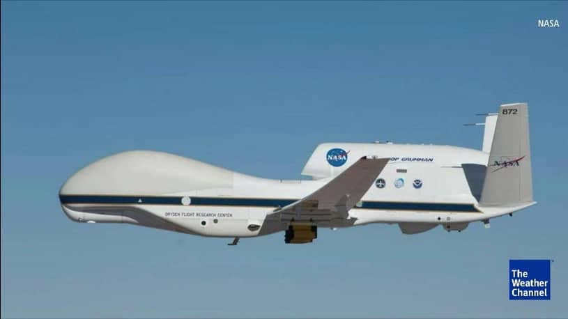
In recent years, Unmanned Aerial Vehicles (UAVs), commonly known as drones, have emerged as a valuable tool for hurricane monitoring. These remotely operated aircraft can be equipped with various sensors and instruments to collect data in challenging atmospheric conditions, further enhancing our understanding of the storm.
UAVs are particularly useful for conducting close-range observations of hurricanes, providing detailed measurements of temperature, humidity, wind patterns, and other parameters within the storm’s core and surrounding areas. Their agility and flexibility allow them to fly at lower altitudes and into regions that are inaccessible or too dangerous for manned aircraft.
By deploying UAVs into hurricanes, meteorologists can obtain high-resolution data that complements the information gathered from satellites and Hurricane Hunters. This multidimensional approach contributes to more accurate modeling of hurricane behavior and enhances our ability to forecast their intensity, track, and potential impacts.
This image is property of s.w-x.co.
Weather Buoys and Stations
Fixed Weather Buoys
Fixed weather buoys are vital instruments used to monitor weather conditions in the ocean. These buoys are anchored to the seafloor and equipped with various sensors that continuously measure atmospheric and oceanographic parameters.
In hurricane monitoring, fixed weather buoys provide valuable data on sea surface temperature, wind speed and direction, wave height, and barometric pressure. This information helps meteorologists assess the oceanic conditions surrounding a hurricane, contributing to a better understanding of its potential for rapid intensification and the development of dangerous storm surges.
Fixed weather buoys also serve as early warning systems in remote or offshore regions. By transmitting real-time data to meteorological agencies, these buoys play a critical role in alerting coastal communities and maritime interests about the approach of a hurricane, enabling timely preparations and evacuation efforts.
Mobile Weather Stations
Mobile weather stations are deployable instruments that can be installed on ships, aircraft, or vehicles to collect meteorological data in areas where fixed buoys or stations are not available. These stations are equipped with sensors similar to those found on fixed weather buoys, allowing them to measure temperature, humidity, wind speed and direction, and atmospheric pressure.
Mobile weather stations are particularly useful for monitoring hurricanes in open water or along the coastlines, where the storm’s impacts are most significant. By obtaining real-time data in these critical areas, meteorologists can enhance their understanding of the storm’s behavior, track, and associated weather patterns.
Additionally, mobile weather stations can be deployed to support hurricane reconnaissance missions conducted by Hurricane Hunters or UAVs. By providing in situ measurements and verification of remote sensing observations, these stations contribute to the accuracy of hurricane forecasts and improve our understanding of their complex dynamics.
Doppler Weather Radar
NEXRAD Doppler Radar
The Next Generation Weather Radar (NEXRAD) is a network of Doppler weather radar systems used extensively by meteorologists to monitor and track hurricanes. These sophisticated radars provide detailed information about a storm’s structure, precipitation patterns, and wind velocities.
By emitting beams of radio waves and analyzing the returning signals, NEXRAD radars can detect the movement and intensity of rain, hail, snow, and other atmospheric particles within a hurricane. This data is crucial for identifying areas of heavy rainfall, strong winds, and potential tornadoes that may accompany the storm, allowing meteorologists to issue timely warnings and advisories.
NEXRAD radar systems are strategically located across the United States, providing coverage over large areas and detecting weather phenomena at different distances. This comprehensive network ensures that meteorologists have access to critical radar data, enabling them to monitor hurricanes from their initial formation to their impact on land.
Weather Surveillance Radar
Weather Surveillance Radar (WSR), also known as weather surveillance doppler radars, are another key tool used in hurricane monitoring. Similar to NEXRAD radars, WSR systems use Doppler technology to measure the speed and direction of precipitation particles within a storm.
WSR radars play a vital role in detecting the potential for severe weather, including intense rain, severe thunderstorms, and tornadoes associated with hurricanes. By tracking the movement and intensity of precipitation bands and cells, meteorologists can assess the storm’s development and identify regions of concern.
These radar systems are typically operated by national meteorological agencies or research institutions and provide valuable data for weather forecasting, research, and public safety. The combination of NEXRAD and WSR radar systems allows meteorologists to have a comprehensive understanding of a hurricane’s convective activity and its potential impact on local communities.
This image is property of www.metoffice.gov.uk.
Weather Balloons
Radiosondes
Weather balloons equipped with radiosondes are critical tools for collecting atmospheric data above the Earth’s surface. These balloons carry instruments that measure temperature, humidity, air pressure, and wind speeds as they ascend through the atmosphere.
Radiosondes are launched from various locations, including weather stations, research laboratories, and meteorological facilities. The data collected by these instruments provide valuable insight into the vertical structure of the atmosphere and help meteorologists identify the atmospheric conditions conducive to hurricane formation and intensification.
By releasing weather balloons equipped with radiosondes ahead of an approaching hurricane, meteorologists can obtain real-time measurements of the atmosphere’s stability, moisture content, and wind patterns. This information enhances our understanding of the environment in which hurricanes develop and evolve, supporting more accurate forecasting and warning efforts.
Weather balloons and radiosondes are particularly useful in areas where surface observations are limited, such as over the open ocean or remote regions. Their ability to sample the atmosphere at different altitudes adds another layer of data to the models used to predict hurricane behavior, improving our ability to anticipate their movements and impacts.
Weather Models
Numerical Weather Prediction (NWP) Models
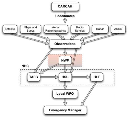
Numerical Weather Prediction (NWP) models are complex computer simulations that use mathematical equations to predict the behavior of the atmosphere. These models take into account a vast array of atmospheric data, including information collected from satellites, radars, weather balloons, and other monitoring systems, to create forecasts for hurricanes and other weather systems.
NWP models simulate the physical processes that govern atmospheric behavior, such as the movement of air masses, the interactions between different layers of the atmosphere, and the transport of heat and moisture. By initializing the model with the most accurate and up-to-date observations, meteorologists can obtain forecasts that represent the best estimate of future weather conditions.
In the case of hurricanes, NWP models play a crucial role in predicting the storm’s track, intensity, and associated weather phenomena, such as heavy rainfall, storm surge, and gusty winds. These models help meteorologists make informed decisions about evacuation orders, emergency response efforts, and the allocation of resources in affected areas.
Ensemble Forecast Models
Ensemble forecast models are a specialized type of NWP models that provide valuable information about the range of possible outcomes for a given weather event, including hurricanes. Instead of relying on a single forecast, ensemble models generate multiple simulations by introducing slight variations in the initial conditions or model parameters.
By running these simulations simultaneously, ensemble models produce a range of possible tracks, intensities, and impacts for a hurricane. The collective output of these simulations, known as an ensemble, offers meteorologists insight into the uncertainties associated with the forecast. This information is crucial for communicating the potential risks and uncertainties to the public, emergency management agencies, and other stakeholders.
Ensemble forecast models help meteorologists assess the likelihood of different scenarios and provide more accurate probabilities for specific weather conditions, such as the likelihood of hurricane landfall, the potential for heavy rainfall, or the occurrence of severe winds. This probabilistic approach enables decision-makers to plan and allocate resources based on a comprehensive understanding of the range of potential outcomes.
This image is property of s.w-x.co.
Storm Surge Gauges
Coastal Water Level Sensors
Coastal water level sensors, often referred to as storm surge gauges, are instruments that measure the height of the ocean’s surface relative to a fixed reference point on land. These gauges are strategically located along coastlines prone to hurricanes and play a crucial role in monitoring and forecasting storm surge, one of the most dangerous and destructive aspects of a hurricane.
During a hurricane, strong winds and low atmospheric pressure can cause the ocean’s surface to rise, resulting in an abnormal increase in water levels along the coast. Storm surge gauges measure these changes, providing valuable real-time information about the magnitude and timing of the storm surge.
The data collected by coastal water level sensors help meteorologists estimate the potential impact of storm surge on different coastal areas and issue timely warnings to vulnerable communities. By tracking the rise and fall of water levels, meteorologists can monitor the storm surge in real time and provide accurate forecasts and advisories to coastal residents, emergency management agencies, and other stakeholders.
Coastal water level sensors are an essential component of hurricane monitoring and preparedness, enabling coastal communities to take appropriate measures to protect lives and property in the face of a potentially devastating storm surge.
Ocean Buoy Networks
TSUNAMIBUOY
TSUNAMIBUOY is a specialized ocean buoy network designed to detect and monitor tsunamis, but it also provides valuable data for hurricane monitoring. These buoys are equipped with various sensors that measure parameters such as sea surface temperature, wave height, and ocean currents.
In the context of hurricanes, TSUNAMIBUOY buoys contribute to our understanding of the oceanic conditions surrounding a storm. By measuring sea surface temperature and other oceanic parameters, meteorologists can analyze the interaction between the hurricane and the underlying ocean, influencing the storm’s intensity and potential for rapid intensification.
TSUNAMIBUOY buoys also help to validate satellite observations and provide additional data points for numerical weather prediction models. Their continuous monitoring of the ocean environment allows meteorologists to track changes in sea surface temperature and other oceanic variables, enabling them to refine their hurricane forecasts and issue more accurate warnings.
Global Telecommunications System (GTS)
The Global Telecommunications System (GTS) is a worldwide network that facilitates the exchange of meteorological and other environmental data between meteorological agencies and other users. This network plays a vital role in hurricane monitoring by ensuring the timely and reliable transmission of real-time data from a variety of observing platforms, including satellites, radars, weather stations, and buoys.
Through the GTS, meteorological agencies can access the latest observations from multiple sources, allowing for more accurate analysis and forecasting of hurricanes. The data exchanged through this system includes satellite imagery, radar observations, atmospheric soundings, buoy measurements, and other meteorological data.
The GTS also provides a mechanism for disseminating hurricane forecasts, warnings, and advisories to meteorological agencies and other users worldwide. This global coordination and sharing of information contribute to the early detection, accurate tracking, and effective response to hurricanes, mitigating their impacts on vulnerable communities.
This image is property of www.hurricanescience.org.
Data Buoy Arrays
PIRATA Buoy Array
The PIRATA (Prediction and Research Moored Array in the Tropical Atlantic) buoy array is a multinational initiative aimed at monitoring and understanding climate variability and tropical Atlantic Ocean dynamics. While its primary focus is not hurricane monitoring, the information collected by the PIRATA buoys contributes to our understanding of oceanic conditions conducive to hurricane formation and development.
The PIRATA buoys are deployed in regions of the tropical Atlantic Ocean known as the “main development region” for hurricanes. These buoys are equipped with sensors that measure various variables, including sea surface temperature, wind speed and direction, humidity, and ocean currents.
The data collected by the PIRATA buoy array help meteorologists identify and analyze the factors that influence hurricane formation, such as the presence of warm oceanic waters and the interaction with the atmosphere. This information enhances our understanding of hurricane genesis and provides valuable insights into the environmental conditions that favor their development.
Deep-ocean Assessment and Reporting of Tsunamis (DART)
The Deep-ocean Assessment and Reporting of Tsunamis (DART) buoy system is primarily designed to detect and monitor tsunamis, but it also contributes to hurricane monitoring efforts. The DART system consists of a network of buoys that measure changes in water pressure caused by tectonic activity or oceanic disturbances, such as hurricanes.
By recording changes in water pressure, DART buoys can identify the occurrence and intensity of tsunami events triggered by undersea earthquakes or volcanic eruptions. However, they can also provide valuable information about the oceanic conditions associated with hurricanes, such as wave heights, wave periods, and changes in sea level.
While not specifically designed for hurricane monitoring, the data collected by the DART buoys contribute to our understanding of the storm’s impact on the ocean and its potential for generating dangerous waves and storm surge. This information, combined with observations from other monitoring systems, helps meteorologists assess the coastal hazards associated with hurricanes and issue appropriate warnings and advisories.
Global Navigation Satellite System (GNSS)
Global Positioning System (GPS)
The Global Positioning System (GPS), a part of the Global Navigation Satellite System (GNSS), plays a crucial role in hurricane monitoring by providing precise positioning and timing information. While not directly used to monitor hurricanes, GPS data contributes to the accuracy of various monitoring systems and helps improve our understanding of hurricane behavior.
GPS receivers located on the ground, aboard aircraft, or on other platforms can collect valuable data on air moisture content, atmospheric stability, and other atmospheric parameters. This data enhances our understanding of the upper-level environment surrounding a hurricane and provides valuable information for forecast models.
GPS data is also used in combination with other observations to improve the accuracy of hurricane track forecasts. By precisely tracking the position and movement of GPS receivers on aircraft, satellites, or weather stations, meteorologists can estimate the strength and location of atmospheric features affecting a hurricane’s movement, such as high-pressure systems or steering currents.
In addition to its direct use in hurricane monitoring, GPS plays a vital role in supporting the overall infrastructure and coordination of meteorological operations. It enables precise timing synchronization between different observing systems, facilitates data transmission, and contributes to the accuracy of various weather monitoring instruments.
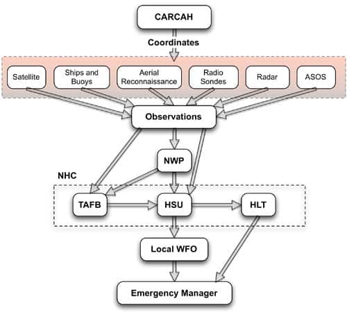
By harnessing the extensive capabilities of satellites, aircraft, buoys, radars, weather models, and other monitoring tools, meteorologists can comprehensively monitor hurricanes and improve our understanding of their behavior and potential impacts. This wealth of information ultimately helps protect lives and property by enabling more accurate forecasts, timely warnings, and effective response efforts in the face of these powerful natural phenomena.
This image is property of www.hurricanescience.org.


