We’ve all relied on weather forecasts at some point, whether it’s to plan our outdoor activities or decide what to wear for the day.
But have you ever wondered how these forecasts are generated? In this article, we’ll explore the weather model that the National Oceanic and Atmospheric Administration, or NOAA, uses to provide accurate and reliable weather predictions.
By understanding the model behind the forecasts, we can gain a deeper appreciation for the science and technology that goes into predicting the ever-changing weather patterns.
So, let’s dive in and unravel the mystery of the weather model employed by NOAA!
Introduction
Welcome to our comprehensive article on the weather models the National Oceanic and Atmospheric Administration (NOAA) uses. As a trusted authority in weather forecasting, NOAA relies on a sophisticated ensemble of mathematical models to provide accurate and timely forecasts.
In this article, we will explore some of the critical weather models employed by NOAA, including the Global Forecast System (GFS), North American Mesoscale Forecast System (NAM), Hurricane Weather Research and Forecasting Model (HWRF), WaveWatch III (WW3), Rapid Refresh (RAP), High-Resolution Rapid Refresh (HR), Short-Range Ensemble Forecast (SREF), and CMC Global Deterministic Prediction System (GDPS).
Global Forecast System (GFS)
Overview
The Global Forecast System (GFS) is one of NOAA’s primary weather models, providing forecasts for the entire globe. Developed by the National Centers for Environmental Prediction (NCEP), the GFS considers atmospheric, oceanic, and land surface data to generate weather predictions. It utilizes advanced numerical techniques to simulate the behavior of the Earth’s atmosphere and predict weather patterns up to 16 days in advance.
Development
The development of the GFS began in the 1990s and has since undergone continuous improvements and updates. It incorporates state-of-the-art atmospheric physics, including the representation of clouds, precipitation, and radiation processes. The model is run multiple times a day, assimilating a vast amount of observational data from weather stations, satellites, aircraft, and other sources to continually improve its forecasts’ accuracy.
Data Assimilation
The GFS employs a sophisticated data assimilation system that integrates observed atmospheric and oceanic data into the real-time model. This process helps to correct and refine the initial conditions used for forecasting, resulting in more accurate predictions. By assimilating data from a wide range of sources, including weather balloons, buoys, and remote sensing instruments, the GFS ensures that up-to-date information is incorporated into its simulations.
Spatial Grid and Resolution
The GFS utilizes a global grid system with a grid spacing of approximately 13 kilometers. This means that the Earth’s surface is divided into numerous grid cells, each covering an area of approximately 13 square kilometers. This level of resolution allows the model to capture fine-scale weather features, such as individual storm systems, frontal boundaries, and local temperature variations.
Ensemble Forecasting
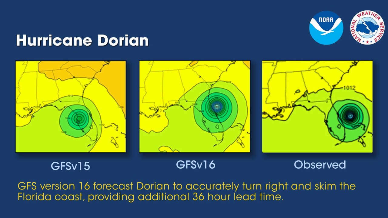
One of the unique features of the GFS is its ensemble forecasting capability. Instead of generating a single forecast, the model creates multiple forecasts, each with slightly different initial conditions. These ensemble members help to represent the uncertainties inherent in weather prediction. By analyzing the spread and consistency of the ensemble members, meteorologists can gain insight into the likelihood and range of possible weather outcomes.
This image is the property of www.ncei.noaa.gov.
North American Mesoscale Forecast System (NAM)
Overview
The North American Mesoscale Forecast System (NAM) is a high-resolution weather model developed by NOAA’s NCEP. It focuses on providing detailed forecasts for specific regions within North America. The NAM has a higher resolution than the GFS, allowing it to capture smaller-scale weather phenomena such as thunderstorms, localized precipitation patterns, and wind gusts.
Development
The NAM has evolved over the years to incorporate advancements in modeling techniques and improvements in data assimilation. It utilizes a combination of numerical weather prediction algorithms, atmospheric physics schemes, and observational data to generate forecasts with a lead time of up to three days.
Data Assimilation
Like the GFS, the NAM relies on a data assimilation system incorporating various observations into its forecast models. These observations come from weather stations, satellites, radar systems, and other sources. By merging the observed data with the model’s initial conditions, the NAM produces more accurate and reliable forecasts.
Spatial Grid and Resolution
The NAM employs a nested grid system, with a higher-resolution grid embedded within a coarser global grid. The inner grid covers the North American continent with a spatial resolution of approximately 5 kilometers, enabling the model to capture localized weather features more effectively. This level of resolution is beneficial for forecasting severe weather events, such as tornadoes and heavy rainfall.
Applications
The NAM is widely used for short-range weather prediction, including forecasting thunderstorms, winter weather, and localized rainfall. Its high resolution makes it valuable for predicting small-scale weather phenomena that may significantly impact local communities. The NAM’s forecasts are leveraged by meteorologists, emergency management agencies, and other stakeholders to enhance preparedness and mitigate the effects of severe weather events.
Hurricane Weather Research and Forecasting Model (HWRF)
Overview
The Hurricane Weather Research and Forecasting Model (HWRF) is a specialized model developed by NOAA and other research institutions to provide accurate forecasts for tropical cyclones, including hurricanes. The HWRF is designed to simulate the entire life cycle of a hurricane, from its formation to its dissipation, with a high level of detail and accuracy.
Development
The development of the HWRF began in the early 2000s, driven by the need for improved hurricane forecasting capabilities. It incorporates advanced physics schemes, such as representing air-sea interactions, convective processes, and hurricane dynamics. The HWRF is continuously updated with new research findings and observational data to enhance its performance.
Data Assimilation
The HWRF assimilates a wide range of observational data to generate accurate hurricane forecasts, including satellite imagery, aircraft reconnaissance data, and data from buoys and other weather instruments. By incorporating these observations into its simulations, the HWRF can better initialize the hurricane’s structure and track, leading to more precise predictions of its intensity and potential impacts.
Spatial Grid and Resolution
The HWRF utilizes a nested grid system similar to the NAM, with a fine-scale inner grid focusing on the hurricane’s core region. This allows the model to capture the intricate details of the storm, including the eye, eyewall, and spiral rainbands.
The HWRF’s spatial resolution is typically on the order of a few kilometers, enabling it to provide accurate forecasts for specific areas affected by a hurricane.
Applications
The HWRF plays a critical role in hurricane forecasting, aiding in predicting a storm’s track, intensity, storm surge potential, and rainfall distribution. Its accurate forecasts enable emergency managers, coastal residents, and other stakeholders to make informed decisions regarding evacuation, resource allocation, and preparedness measures.
The HWRF’s impact extends beyond the United States, as its predictions are also valuable for international partners and organizations involved in hurricane response and planning.
This image is the property of images.foxweather.com.
WaveWatch III (WW3)
Overview
WaveWatch III (WW3) is a numerical model NOAA’s National Centers for Environmental Prediction (NCEP) developed to forecast ocean waves. While primarily used for marine applications, the model provides valuable information for coastal regions and offshore activities.
Development
The development of WaveWatch III began in the early 1990s to accurately simulate the generation, propagation, and dissipation of ocean waves. The model incorporates various physical processes, including wind forcing, wave breaking, and wave-wave interactions, to simulate realistic wave conditions in the global ocean.
Data Assimilation
WaveWatch III assimilates observational data from buoys, ships, and satellites to improve the accuracy of its wave forecasts. The model can adjust its initial conditions and better represent the actual wave state by incorporating information on wave heights, periods, and directions. This data assimilation process contributes to more skillful wave predictions.
Spatial Grid and Resolution
The global implementation of WaveWatch III employs a horizontal grid with a resolution of approximately 10 kilometers. This resolution allows the model to capture regional and large-scale wave phenomena accurately. Also, the model’s higher-resolution versions can be used for specific regions, such as coastal areas or oceanic regions with complex bathymetry, to provide more detailed wave forecasts.
Applications
WaveWatch III provides crucial information for various sectors, including offshore energy production, maritime operations, and coastal engineering. By accurately predicting wave conditions, the model helps optimize the design and operation of offshore structures, aids in maritime navigation and safety and assists in coastal erosion and flood risk assessments. The wave forecasts generated by WaveWatch III contribute to resource management and decision-making processes.
Rapid Refresh (RAP)
Overview
The Rapid Refresh (RAP) model, developed by NOAA’s National Centers for Environmental Prediction (NCEP), focuses on providing highly detailed short-term forecasts for the United States. As its name suggests, RAP provides frequent updates to capture the rapidly evolving atmospheric conditions and guide near-term weather forecasts.
Development
The development of the RAP model started in the late 2000s, driven by the need for more accurate and timely short-term weather predictions. The model incorporates advanced numerical techniques and observational data assimilation to generate hourly forecasts up to 18 hours in advance.
Data Assimilation
RAP assimilates a comprehensive suite of observational data, including surface observations, radar data, and satellite imagery, to initialize and update its forecast simulations. This data assimilation process ensures the model captures the latest atmospheric conditions and provides accurate short-term predictions.
Spatial Grid and Resolution
The RAP model employs a high-resolution horizontal grid with a spacing of approximately 13 kilometers. This fine-scale resolution allows the model to capture small-scale weather phenomena, such as convective cells and boundary layer processes, essential for accurate short-term forecasts.
Applications
RAP’s frequent updates and high-resolution forecasts make it invaluable for various applications, including aviation weather forecasting, severe weather monitoring, and outdoor event planning. Its forecasts inform flight operations, air traffic management, storm prediction, and other time-sensitive activities. RAP’s focus on short-term predictions ensures forecasters have the most up-to-date information to make crucial decisions.
This image is the property of s.w-x.co.
High-Resolution Rapid Refresh (HR)
Overview
The High-Resolution Rapid Refresh (HRRR) model is an enhanced version of the Rapid Refresh (RAP) model, offering even higher-resolution forecasts for the United States. Developed by NOAA’s National Centers for Environmental Prediction (NCEP), the HRRR focuses on capturing small-scale weather features with exceptional detail and accuracy.
Development
The development of the HRRR began in the mid-2000s, building upon the success of the RAP model. It incorporates advanced modeling techniques, improved physical parameterizations, and higher-resolution observational data to provide forecasts with up to 18 hours of lead time.
Data Assimilation
Like the RAP model, the HR assimilates a wide array of observational data, including surface observations, radar data, and satellite imagery. The assimilation process integrates this observed data into the model’s initial conditions, ensuring that the forecast simulations reflect the latest atmospheric state and provide accurate short-term predictions.
Spatial Grid and Resolution
The HRRR employs an excellent horizontal grid with a spacing of around 3 kilometers. This level of resolution allows the model to capture small-scale weather features, such as individual thunderstorms, terrain-induced effects, and urban heat island influences. The HRRR’s high-resolution forecasts provide forecasters and decision-makers with detailed information for localized weather events.
Applications
The HRRR’s high-resolution forecasts have numerous applications, including severe weather prediction, wildfire management, and emergency response planning. Its ability to capture small-scale weather features accurately enables forecasters to identify potential risks and issue timely warnings. Additionally, the HRRR’s detailed forecasts improve situational awareness and support effective decision-making during weather-related emergencies.
Short-Range Ensemble Forecast (SREF)
Overview
The Short-Range Ensemble Forecast (SREF) model is an ensemble forecasting system developed by NOAA’s National Centers for Environmental Prediction (NCEP). It combines multiple forecasts with slightly different initial conditions to provide a probabilistic outlook for short-term weather predictions.
Development
The development of the SREF model began in the late 1990s, aiming to capture uncertainties inherent in weather forecasting and provide a more comprehensive outlook. It incorporates ensemble members generated by perturbing the initial conditions, model physics, and model configurations to represent different plausible weather scenarios.
Data Assimilation
Like other NOAA models, the SREF assimilates observational data from various sources, allowing it to incorporate real-time information into its ensemble members. By assimilating a diverse range of observations, the SREF captures uncertainties associated with the initial atmospheric state, resulting in probabilistic forecasts.
Spatial Grid and Resolution
The SREF utilizes a relatively coarse horizontal grid with a spacing of approximately 32 kilometers. While the grid resolution is coarser than other NOAA models discussed earlier, the SREF’s strength lies in its ensemble approach, which provides insight into possible weather outcomes.
Applications
The probabilistic forecasts generated by the SREF model have broad applications in weather-sensitive sectors, such as agriculture, aviation, and emergency management. By quantifying the uncertainty of weather predictions, the SREF helps stakeholders make informed decisions while considering various weather scenarios. Its ensemble outlook is precious for identifying potential risks associated with severe weather, enabling proactive planning and response measures.
This image is the property of www.wpc.ncep.noaa.gov.
CMC Global Deterministic Prediction System (GDPS)
Overview
The CMC Global Deterministic Prediction System (GDPS) is a weather model developed by the Canadian Meteorological Center (CMC). Although not developed by NOAA, the GDPS is widely used and contributes to the global weather modeling efforts undertaken by various meteorological agencies, including NOAA.
Development
The CMC has continuously enhanced the GDPS since its development, incorporating advancements in modeling techniques and assimilation of observational data. Collaborative efforts between NOAA and the CMC ensure that the GDPS aligns with global modeling standards and contributes to the accuracy and reliability of forecasts on a global scale.
Data Assimilation
The GDPS assimilates observational data from multiple sources, including weather stations, satellites, and aircraft, to improve the accuracy of its forecasts. By incorporating up-to-date information into its simulations, the model benefits from a more realistic representation of the initial atmospheric state and provides reliable predictions.
Spatial Grid and Resolution
The GDPS employs a global grid system with a horizontal resolution of approximately 25 kilometers. While less detailed than other high-resolution models, the GDPS provides valuable forecasts on a global scale, aiding in long-range weather prediction and the analysis of large-scale weather patterns.
Applications
The GDPS’s global coverage makes it valuable for a wide range of applications, including climate analysis, long-range forecasting, and identifying large-scale weather patterns. The model’s forecasts contribute to understanding global weather phenomena and support operational meteorology efforts worldwide. The GDPS’s predictions are employed by meteorological agencies, research institutions, and other stakeholders to enhance weather monitoring, global planning, and decision-making processes.
Concluding Remarks
In conclusion, NOAA utilizes advanced weather models to provide accurate and timely forecasts. The Global Forecast System (GFS), North American Mesoscale Forecast System (NAM), Hurricane Weather Research and Forecasting Model (HWRF), WaveWatch III (WW3), Rapid Refresh (RAP), High-Resolution Rapid Refresh (HR), Short-Range Ensemble Forecast (SREF), and CMC Global Deterministic Prediction System (GDPS) are among the critical models employed by NOAA.
These models combine observational data assimilation, advanced physics schemes, and high-resolution spatial grids to generate forecasts for global, regional, and localized weather phenomena.
These forecasts are crucial in supporting decision-making processes, enhancing preparedness, and mitigating the impact of severe weather events. By continuously advancing and refining their models, NOAA remains at the forefront of weather forecasting, ensuring the safety and well-being of communities worldwide.
This image is the property of ewscripps.brightspotcdn.com.


